Assessing carbon storage in Florida’s Everglades
Paul Christianson, Ecosystem Services Analyst and Cody Kiefer, GIS Specialist
When most people envision forests, they imagine sweeping terrestrial landscapes, such as the massive Boreal Taiga of Siberia, the Amazon rainforest, or the majestic redwoods of California. These vital and diverse landscapes around the world are cherished for their beauty and the benefits they provide. Much of our work at Winrock focuses on addressing the threats these forests face and in developing financing opportunities to protect at-risk forests and address climate change. We are proud to be a part of these invaluable efforts, which are vital to build a more sustainable future.
But what often surprises folks is that some of the most remarkable forests in the world — and those most valuable for combating climate change — are in fact located in aquatic systems. These forests are populated by trees known as mangroves, a name for the approximately 80 woody plant species that are capable of living in the ever-shifting coastal saltwater zones across the world’s tropical and subtropical zones.
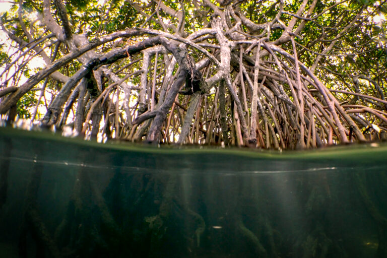
Mangroves thrive in tidal mudflats and grow upwards. After their flowers are pollinated, their seeds immediately germinate into seedlings, called propagules; they then fall off and are swept away by currents. Mangroves are easily identified by their distinctive mesh of aboveground “breathing” roots, called pneumatophores, that resemble knees. These roots, which have pores that allow oxygen to enter underground tissues, provide valuable environmental services. They thickly and deeply penetrate the coast around them, protecting the land from storm surges and coastal erosion while providing valuable nursing habitat for the juveniles of any number of aquatic animals and nesting habitat for birds, insects, and more. The U.S. alone has roughly 800 square miles of mangroves, largely in the Everglades National Park in South Florida.
Mangroves are fascinating species. They exist in the nexus between land and sea and are capable of filtering salt out of the water and into their roots. In fact, they’re treated almost like supermarkets by the communities that live near them, due to their ability to help produce fish, shellfish, timber, charcoal, honey and more. Research shows that even a few mangrove clusters can help prevent coastal erosion.
Mangroves, however, are often misunderstood by the general public. The lands they occupy are often very productive or in valuable coastal locations, and so are often targeted for conversion to aquaculture and other uses. In his book “The Log from the Sea of Cortez,” author John Steinbeck wrote that despite being fascinating to look into, “…We felt that we were watching something horrible. No one likes the mangroves.” Now, this is a shame for a great many reasons, not the least of which is that mangrove forests are invaluable for efforts to fight climate change. On average, they store 3-4 times more carbon as terrestrial tropical forests. They also sit upon valuable peat soils which, when wetted, store more carbon per hectare than any other landscape in the world. The economic benefits of restoring or strengthening mangrove ecosystems are difficult to overstate, yet for years they remained vastly undervalued for the services they provide. Early Florida settlers considered the Everglades to be swamp land, and targeted them for conversion to farmland by digging canals that drew off the flow of water from further north. More recently, residential development has drawn off further water supply.
Fortunately, though, the U.S. Congress authorized creation of the Comprehensive Everglades Restoration Plan in 2000, with the goals of restoring and protecting freshwater delivery that the mangroves require to maintain a vibrant and healthy ecosystem. Guided by a unique federal-state partnership, the freshwater access CERP will ensure over the next few decades is intended to restore the Everglades ecosystem to a more natural state and reverse some of the negative ecological effects of the intense hydrological alteration that occurred in the 20th century.
The Everglades Carbon Assessment
To contribute to restoration of the ‘Glades, as they are known regionally, Winrock’s Ecosystem Services team is collaborating with The Everglades Foundation on a complex but important project. It involves estimating the total carbon emissions and removals associated with the greater Everglades region, along with the impacts that CERP-related work will have. Currently in its second phase, our Winrock team is now calculating the benefits of carbon storage that will directly result from the restored freshwater access CERP will provide.
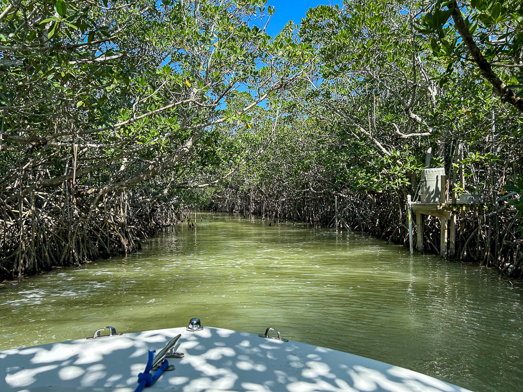
We recently traveled to South Florida ─ and boated through a tiny sliver of the Everglades backcountry ─ to take a first-hand look at this remarkable ecosystem and to deepen our collaboration with key researchers at a workshop hosted by Florida International University in Miami. In addition to conducting a site visit into the park, we participated in an important workshop with researchers on mangroves, including Winrock’s partners, The Everglades Foundation and FIU.
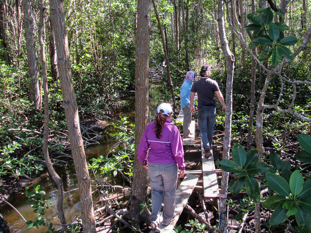
Mangroves are complex systems that vary in size, density and species throughout the park, and every bit of information gathered, we felt, could prove critical to our work. On a hot and sunny February morning, we travelled with Foundation staff to some key sites around the park by boat, launching from the northern coast of Key Largo – a large island on the northern end of the Florida Keys – and motoring north to Joe Bay and the Taylor River. In this part of the park, mangrove trees have a shorter, shrubbier appearance. Many are no taller than six or seven feet. This is the result of many factors, including a lesser flow of freshwater delivered from the north, but also fascinatingly, because the southern tip of the ‘Glades ─ on the Florida Bay end, near the Keys ─ is better protected from hurricanes, which deposit large amounts phosphorus on the ecosystem than the more exposed side that fronts the Gulf of Mexico. As our boat took us around the southern tip of Florida and north into the depths of the Shark River, we were overwhelmed by how much taller the trees were, even in comparison with the same species we saw further east. Some trees in this area were over 60 feet tall. It was striking to be in such a dense forest yet surrounded by wetlands and rivers all around us.
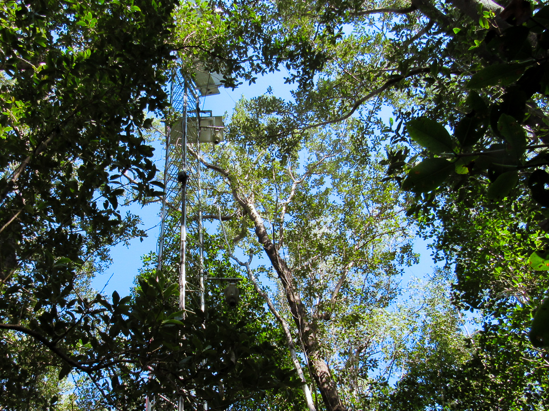
As experts in quantifying the benefits of ecosystem services, taking this opportunity to understand the variation and diversity in the size and structure of the mangrove forests proved invaluable for our analysis. Our site visit also afforded us the opportunity to see dozens of animal species from dolphins to manatees, crocodiles and pelicans. After a brief detour to visit an eddy flux tower used to measure carbon dioxide in the air, we returned to Key Largo and finalized our preparatory work for the FIU workshop the next day.
Blue Carbon Research: Sharing and Learning
While the field visits were important, the main event of our trip was a mangrove workshop hosted by FIU. The university’s campus is situated on the eastern edge of the Everglades, so it’s perhaps no surprise that the school is home to some of the world’s most renowned mangrove researchers. Our workshop also attracted top mangrove researchers from other Southern universities and organizations, ranging from Tulane University to East Carolina University and the South Florida Water Management District. These experts joined us to share their knowledge and collaboratively develop a plan for quantifying the carbon benefits of the huge and ongoing CERP endeavor. Discussions touched on key variables influencing mangrove reach and growth, and, perhaps most importantly, provided us with the foundational knowledge and data we need to complete this project. Key takeaways from our perspective included:
- The need to incorporate carbon stocks, sequestration rates, and fluxes into our analysis to account for the complex exchange of greenhouse gases that takes place in wetland systems;
- The importance of considering spatial scale and uncertainty/variability of data in our results;
- The need to consider the variability of soil conditions, mangrove composition and freshwater flow across different spatial gradients within the Everglades; and
- The importance of considering external influencers such as sea level rise and severe storms, as well as the potential for mangrove recovery in our projection of future mangrove trends.
After almost five hours of intense discussions, we did it: We left with a draft roadmap for collaboratively tackling the carbon measurement problem, along with reams of data to help us achieve our goal of tallying the mangrove-specific carbon impacts of CERP.
Winrock’s work, combined with that of other experts undertaking mangrove research around the world, ultimately will help us provide an accurate analysis of the benefits from CERP. That in turn, will contribute further data- and science-based evidence of the wondrous benefits provided by those very trees that Mr. Steinbeck once disparaged. We are proud to contribute one component of a solution to address the role of forests in climate change mitigation.

Ecosystem Services Analyst

GIS Specialist
Related Projects